
Kunyu Wanguo Quantu pioneers new cartographic mode
A printed version of Kunyu Wanguo Quantu (A Map of the Myriad Countries of the World) is preserved in the “Ming: The Golden Empire” collection of the Nanjing Museum.?(PHOTO: Official website of the Nanjing Museum)
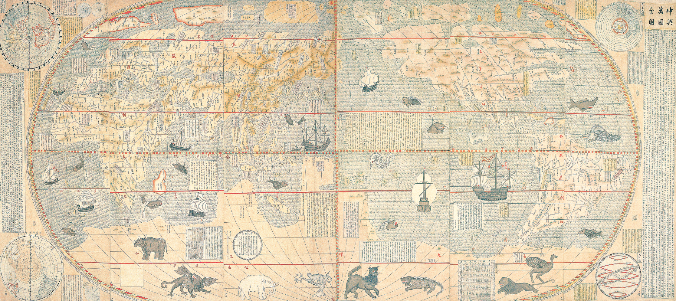
Kunyu Wanguo Quantu (A Map of the Myriad Countries of the World), printed in China at the request of the Wanli Emperor in 1602 by Matteo Ricci, Zhong Wentao, and the technical translator Li Zhizao, is the earliest known Chinese world map with the style of European maps of exceptionally high-quality. It propelled the development of geography in China and facilitated cultural exchange between China and the West, standing as a precious artifact in the global history of cartography.
During the ancient period in China, a yutu was the term used by Chinese people to refer to a map. It records the spatiotemporal vicissitudes of history, encapsulates significant historical moments, and reconstructs scenes in the past. It is an invaluable historical and cultural heritage.
Yutu is a type of geographic map. “Yu” refers to the base of a carriage, which is used to carry objects. Since maps carry mountains, rivers, towns, and various geographical features, ancient people referred to maps as “yutu”.
Kunyu Wanguo Quantu?is elliptical, using an equal-area projection. Its meridians are curved lines symmetric to the central meridian, while the lines of latitude are parallel to the equator, including the Tropics of Cancer and Capricorn.
Kunyu Wanguo Quantu?depicts the relative positions of the five known continents at that time — Asia, Africa, Europe, the Americas, and the great and unknown southern continent. The coastlines of Asia, Europe, Africa, and the Americas are relatively accurate. Oceania is not shown on the map due to the then-undiscovered continent of Australia. Additionally, since Antarctica had not yet been explored, its depiction on the map is based on European speculations about the "Terra Australis Incognita", resulting in an exaggerated size compared to the actual landmass.
Outside the corners of the elliptical world map frame of?Kunyu Wanguo Quantu, there are four circular inset maps, serving as a supplement to the main map. The upper right corner depicts the Nine Spheres of Heaven, and the lower right corner shows a Celestial Globe. The upper left corner illustrates the Northern Hemisphere, and the lower left corner displays the Southern Hemisphere.
The map provides the most detailed depiction of East Asia among the world maps of that time. Ricci drew from the maps of Abraham Ortelius, the creator of the first modern atlas, and Ming Dynasty Chinese maps and land surveys such as Luo Hongxian's?Guangyu Tu (Enlarged terrestrial atlas),?Daming Yitong Zhi (Records of the Unified Great Ming), and?"Yang Ziqi Bayu Ditu" (Map of China with Notes Written by Yang Ziqi), as well as?Gujin Xingsheng Zhi Tu (Map of advantageous terrain past and present).
Ricci changed the pattern of placing Europe in the center of the world map and supplanted it with East Asia on this map.
In addition to geographic names,?Kunyu Wanguo Quantu?is covered with lively accounts and annotations, documenting customs, history, and local specialties from around the globe. The maritime zones of the map also feature sailboats and marine animals, including whales and turtles. In the Southern Hemisphere part, one can even find tropical animals like rhinoceroses, sloths, elephants, crocodiles, lions, and ostriches.
Flanked by detailed explanations, commentaries, and prefaces written by Ricci, the map provides extensive knowledge about the Earth and Western cartographic projection methods. The right side elaborates on the equator, North and South Poles, and the concept of five continents. On the left side, an article includes a table showing the distance between the planets and the Earth and explanations of varying lengths of days and nights, marking the first appearance of “the Earth” in the Chinese language.
Kunyu Wanguo Quantu?revolutionized the traditional Chinese cosmological philosophy of the square, flat Earth and round heaven and introduced the concept of a spherical Earth to China. As a result, a series of circular world maps emerged in China from then on.
In addition, many geographical transliterations by Ricci are still in use nowadays, such as Yaxiya (Asia), Dizhong Hai (the Mediterranean Sea), Niluo He (the Nile River), Nanji (Antarctica), Beiji (Arctic), and Chidao (the equator).
Source: CSGPC, Voice?of?CAST